A new study has revealed a previously unexplored ionospheric connection between the massive eruption of the Tonga volcano, a submarine volcano in the South Pacific, on 15 January 2022 and the formation of Equatorial Plasma Bubbles (EPBs) or an ionospheric phenomenon near the Earth’s geomagnetic equator at night time over the Indian subcontinent.
It highlights how volcanic eruptions can trigger ionospheric disturbances and space weather that affect satellite communication and navigation systems.
In today’s world, satellite-based communication and navigation systems are critical for numerous sectors. Understanding how natural disasters, like volcanic eruptions, can impact the ionosphere is essential for predicting and mitigating disruptions in these systems. While previous studies have established that EPBs can disrupt satellite signals, the role of terrestrial events in shaping space weather has not been explored.
On January 15, 2022, the Tonga volcano located 65 km (40 mi) north of Tongatapu, Tonga‘s main island in Polynesia, erupted with extraordinary force sending shock waves through the atmosphere. Scientists were intrigued by the subsequent formation of EPBs in the evening hours over the Indian region.
Scientists at Indian Institute of Geomagnetism (IIG) Navi Mumbai, an autonomous institute of Department of Science and Technology explored the connection between the Tonga volcanic eruption and the EPBs.
They found that the eruption produced strong atmospheric gravity waves that propagated into the upper atmosphere, triggering ionospheric conditions favorable to trigger EPBs. They used ionosonde observations from Tirunelveli and Prayagraj to detect spread-F traces –a phenomenon in the ionosphere where electron density become irregular causing spread in radio signals and leading to fading or disruptions in communications. Concurrently, satellite data from Swarm B and C confirmed significant electron density depletions, directly linked to the formation of EPBs.
The scientists analyzed various atmospheric and ionospheric data to understand how disturbances triggered by the eruption led to the generation of EPBs.
Observations from NASA’s Ionospheric Connection Explorer (ICON) (wind, ion density, and temperature) and Swarm satellites provided a comprehensive view of the ionospheric changes during the event, confirming that the eruption-induced gravity waves played a crucial role in initiating these plasma instabilities.
Plasma blobs, as well as enhanced Pre- Reversal Enhancement (PRE) –sharp increase in the ionospheric eastward electric field in the dusk sector before it turns to westward in the late-night hours, triggered by atmospheric disturbances were also detected.
Further analysis of iso-frequency and Total Electron Content (TEC) data from Global Navigation Satellite System (GNSS) measurements across the Indian region revealed gravity wave-like oscillations/Traveling Ionospheric Disturbances (TIDs) moving across Indian longitudes in the equatorial ionosphere.
This indicated that the volcanic eruption had a widespread impact on the ionosphere and acted as seeding mechanisms for EPB generation.
This comprehensive utilization of data from multiple sources gave the researchers a multi- dimensional view of the ionospheric disturbances.
By combining ground-based and satellite data, the study published in “Journal of Geophysical Research: Space Physics” offers new insights into how natural disasters like volcanic eruptions can significantly influence space weather, affecting satellite communication and navigation systems.
The Tonga Volcano identified as a cause for these ionospheric disturbances is a real-world example showing the need for monitoring space weather conditions in the aftermath of major geological events, adding to existing knowledge of ionospheric dynamics.
The research by the team consisting of R K Barad, S Sripathi, S Banola, and K Vijaykumar, underscores the role of terrestrial events in shaping space weather, adding to existing knowledge of ionospheric dynamics.
The connection established between geological events and ionospheric dynamics is important for satellite communication and relevant for sectors like defense, agriculture, aviation, disaster management, and any other areas that rely on Global Positioning Systems (GPS) and satellite-based technologies.
The study can help improve forecasting of ionospheric disturbances leading to better early warning systems that involve satellite signal interference, benefiting fields like navigation, aviation, and military operations. This will allow governments and industries to better prepare for and mitigate disruptions in essential services like GPS, air traffic control, and satellite communications.

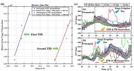
Figure: (a) Brightness temperature (BT) perturbation at a 4.3-micron wavelength obtained from the AIRS instrument on NASA’s Aqua satellite, with the pink triangle indicating the location of the Tonga volcano. (b) Distance-time plot of Total Electron Content (TEC) perturbations observed over Colombo, Tirunelveli, Bangalore, and Hyderabad, with blue and red dots representing the first (∼452 m/s) and second (∼406 m/s) Traveling Ionospheric Disturbances (TIDs). (c) Temporal variation of the F-layer base height (h’F) over Tirunelveli and Prayagraj for January 2022, illustrating the ionospheric response following the eruption. This figure sequence captures the progression from the atmospheric disturbance caused by the Tonga eruption to its impact on the ionosphere over India.
Comments are closed.