Southwest monsoon is likely to advance into remaining parts of south Arabian Sea, some parts of central Arabian Sea, remaining parts of Kerala & Lakshadweep

New Delhi: According to the National Weather Forecasting Centre of the India Meteorological Department (IMD):

(Friday04June 2021, MORNING, Time of Issue: 0800 hours IST) 

ALLINDIAWEATHER SUMMARYAND FORECASTBULLETIN


SignificantWeatherFeatures


Text Box: ♦	The Northern Limit of Monsoon (NLM) continues to pass through lat. 10°N/ Long. 60°E, lat. 10°N/ Long. 70°E, Kochi, Palayamkottai,lat.90°N/Long.80°E,12°N/85°E,14°N/90°Eand17°N/94°E.♦	Southwest monsoon is likely to advance into remaining parts of south Arabian Sea, some parts of central Arabian Sea, remaining parts ofKerala&Lakshadweep,somemorepartsofTamilNadu&Puducherry,somepartsofcoastal&southinteriorKarnataka,Rayalaseemaandsomemoreparts ofsouthandCentralBayof Bengalduringnext24 hours.♦	Due to strengthening of lower level southwesterly winds, widespread rainfall activity very likely over Northeastern states during next 5days. Isolated heavy rainfall very likely over Arunachal Pradesh during 04th-06th; Assam & Meghalaya during 04th-07th and Nagaland,Manipur,Mizoram&Tripuraon 05th&06th.♦	A Western Disturbance as a trough in mid & upper tropospheric westerlies with its axis at 7.6 km above mean sea level runs roughlyalong longitude 74°E to the north of latitude 28°N. Under its influence, isolated to scattered rainfall accompanied with thunderstorm,lightningand gustywinds very likely overpartsofWesternHimalayan Region &adjoining plains ofNorthwestIndiaduringnext2days.♦	Under the influence of a trough at mean sea level off Karnataka-Kerala coasts and strengthening of westerly wind in lower troposphericlevels; scattered to widespread rainfall accompanied with thunderstorm, lightning and gusty winds. Isolated heavy rainfall very likely overKeralaand Karnatakaduringnext2days.


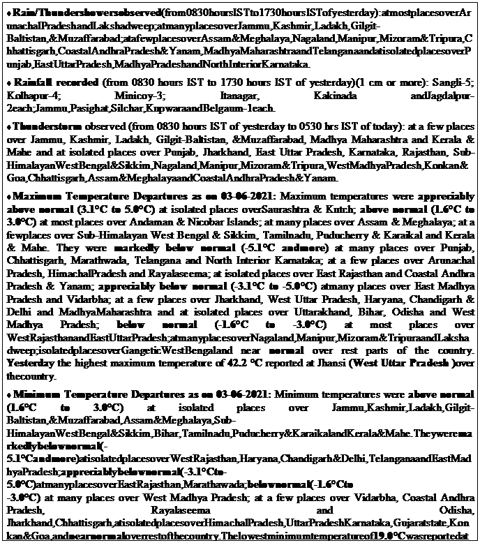
MainWeatherObservations

Text Box: ♦	Rain/Thundershowersobserved(from0830hoursISTto1730hoursISTofyesterday):atmostplacesoverArunachalPradeshandLakshadweep;atmanyplacesoverJammu,Kashmir,Ladakh,Gilgit-Baltistan,&Muzaffarabad;atafewplacesoverAssam&Meghalaya,Nagaland,Manipur,Mizoram&Tripura,Chhattisgarh,CoastalAndhraPradesh&Yanam,MadhyaMaharashtraandTelanganaandatisolatedplacesoverPunjab,EastUttarPradesh,MadhyaPradeshandNorthInteriorKarnataka.♦	Rainfall recorded (from 0830 hours IST to 1730 hours IST of yesterday)(1 cm or more): Sangli-5; Kolhapur-4; Minicoy-3; Itanagar, Kakinada andJagdalpur-2each;Jammu,Pasighat,Silchar,KupwaraandBelgaum-1each.♦	Thunderstorm observed (from 0830 hours IST of yesterday to 0530 hrs IST of today): at a few places over Jammu, Kashmir, Ladakh, Gilgit-Baltistan, &Muzaffarabad, Madhya Maharashtra and Kerala & Mahe and at isolated places over Punjab, Jharkhand, East Uttar Pradesh, Karnataka, Rajasthan, Sub-HimalayanWestBengal&Sikkim,Nagaland,Manipur,Mizoram&Tripura,WestMadhyaPradesh,Konkan&Goa,Chhattisgarh,Assam&MeghalayaandCoastalAndhraPradesh&Yanam.♦	Maximum Temperature Departures as on 03-06-2021: Maximum temperatures were appreciably above normal (3.1°C to 5.0°C) at isolated places overSaurashtra & Kutch; above normal (1.6°C to 3.0°C) at most places over Andaman & Nicobar Islands; at many places over Assam & Meghalaya; at a fewplaces over Sub-Himalayan West Bengal & Sikkim, Tamilnadu, Puducherry & Karaikal and Kerala & Mahe. They were markedly below normal (-5.1°C andmore) at many places over Punjab, Chhattisgarh, Marathwada, Telangana and North Interior Karnataka; at a few places over Arunachal Pradesh, HimachalPradesh and Rayalaseema; at isolated places over East Rajasthan and Coastal Andhra Pradesh & Yanam; appreciably below normal (-3.1°C to -5.0°C) atmany places over East Madhya Pradesh and Vidarbha; at a few places over Jharkhand, West Uttar Pradesh, Haryana, Chandigarh & Delhi and MadhyaMaharashtra and at isolated places over Uttarakhand, Bihar, Odisha and West Madhya Pradesh; below normal (-1.6°C to -3.0°C) at most places over WestRajasthanandEastUttarPradesh;atmanyplacesoverNagaland,Manipur,Mizoram&TripuraandLakshadweep;isolatedplacesoverGangeticWestBengaland near normal over rest parts of the country. Yesterday the highest maximum temperature of 42.2 °C reported at Jhansi (West Uttar Pradesh )over thecountry.♦	Minimum Temperature Departures as on 03-06-2021: Minimum temperatures were above normal (1.6°C to 3.0°C) at isolated places over Jammu,Kashmir,Ladakh,Gilgit-Baltistan,&Muzaffarabad,Assam&Meghalaya,Sub-HimalayanWestBengal&Sikkim,Bihar,Tamilnadu,Puducherry&KaraikalandKerala&Mahe.Theyweremarkedlybelownormal(-5.1°Candmore)atisolatedplacesoverWestRajasthan,Haryana,Chandigarh&Delhi,TelanganaandEastMadhyaPradesh;appreciablybelownormal(-3.1°Cto-5.0°C)atmanyplacesoverEastRajasthan,Marathawada;belownormal(-1.6°Cto-3.0°C) at many places over West Madhya Pradesh; at a few places over Vidarbha, Coastal Andhra Pradesh, Rayalaseema and Odisha, Jharkhand,Chhattisgarh,atisolatedplacesoverHimachalPradesh,UttarPradeshKarnataka,Gujaratstate,Konkan&Goa,andnearnormaloverrestofthecountry.Thelowestminimumtemperatureof19.0°CwasreportedatMedak(Telangana)andBidar(NorthInteriorKarnataka)overtheplainsofthecountry.


Text Box: ♦	The Northern Limit of Monsoon (NLM) continues to pass through lat. 10°N/ Long. 60°E, lat. 10°N/ Long. 70°E, Kochi, Palayamkottai, lat. 90°N/ Long.80°E,12°N/85°E,14°N/90°Eand17°N/94°E.♦	Southwest monsoon is likely to advance into remaining parts of south Arabian Sea, some parts of central Arabian Sea, remaining parts of Kerala &Lakshadweep,somemorepartsofTamilNadu&Puducherry,somepartsofcoastal&southinteriorKarnataka,RayalaseemaandsomemorepartsofsouthandCentralBayofBengalduringnext24hours.♦	TheWesternDisturbanceasatroughinmid&uppertroposphericwesterlieswithitsaxisat7.6kmabovemeansealevelnowrunsroughlyalonglongitude74°Etothenorthoflatitude28°N.♦	ThecycloniccirculationovercentralPakistan&neighbourhoodextendingupto1.5kmabovemeansealevelpersists.♦	ThecycloniccirculationovernorthChhattisgarh&neighbourhoodandextendsupto1.5kmabovemeansea levelpersists.♦	ThecycloniccirculationoverEastcentralArabianSeaoffKarnatakacoastextendingupto3.1kmabovemeansealevelpersists.♦	ThetroughatmeansealeveloffKarnataka-Keralacoastspersists.♦	ThecycloniccirculationoverEquatorialIndianOcean&adjoiningcentralpartsofSouthBayofBengalbetween3.1km&4.5kmabovemeansealevelpersists.♦	The east-west shear zone from Southwest Arabian Sea to Southeast bay of Bengal across extreme southern peninsula along Latitude 8°N at 3.1 km abovemeansealevelpersists.♦	Thenorth-southtrough fromTelanganatosouthTamilnaduandextendsupto1.5kmabovemeansealevelpersists.

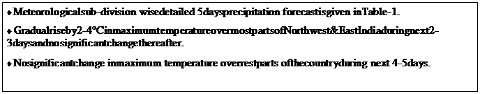
MeteorologicalAnalysis(Basedon0530hoursIST)WeatherForecastfornext5days*upto0830hoursIST of09thJune, 2021

Text Box: ♦	Meteorologicalsub-division wisedetailed 5daysprecipitation forecastisgiven inTable-1.♦	Gradualriseby2-4°CinmaximumtemperatureovermostpartsofNorthwest&EastIndiaduringnext2-3daysandnosignificantchangethereafter.♦	Nosignificantchange inmaximum temperature overrestparts ofthecountryduring next 4-5days.


Text Box: ♦	Fairlywidespread towidespreadrainfall/thunderstormswithheavyrainfallatisolatedplaceslikelyoverNortheast India.♦	Scatteredrainfall/thunderstormswithisolatedheavyfallslikelyover southPeninsularIndiaandIslands.♦	Isolated toscatteredrainfall/thunderstorms likely overEast India.♦	Weather likelytobedryoverremainingpartsofthecountry.

WeatherOutlookfor subsequent2daysfrom09thJune 2021to11thJune2021


WeatherWarningduringnext5days*

04 June (Day 1): ♦ Thunderstorm with lightning & gusty winds (speed reaching 30-40 kmph) very likely at isolated places over East Rajasthan, WestMadhya Pradesh and Telangana and with lightning at isolated places over Jammu & Kashmir, Ladakh, Gilgit-Baltistan & Muzaffarabad, Himachal Pradesh,Uttarakhand, East Madhya Pradesh, Vidarbha, Chhattisgarh, Odisha, Gujarat state, Madhya Maharashtra, Marathwada, Konkan & Goa, Coastal AndhraPradesh&Yanam,Rayalaseema,Coastal&NorthInteriorKarnataka,TamilNadu,Puducherry&KaraikalandKerala&Mahe.

♦ Thunderstorm/Duststormwithlightning&gustywinds(speedreaching30-40kmph)verylikelyatisolatedplacesoverWestRajasthan.

♦  HeavyRainfallatisolatedplacesverylikelyoverArunachalPradesh,Assam&Meghalaya,MadhyaMaharashtra,Konkan&Goa,CoastalAndhraPradesh&Yanam,Telangana,Rayalaseema,Coastal&SouthInteriorKarnataka,TamilNadu,Puducherry&KaraikalandKerala&Mahe.

♦ StrongWind(speed40-50kmphgustingto60kmph)verylikelyoverSouthwest&WestcentralArabianSeaandwithwindspeed40-50kmphoverLakshadweeparea,SoutheastArabianSeaoffKeralacoast.Fishermenareadvisednottoventureintotheseareas.

05June(Day2):♦Thunderstormwithlightning&gustywinds(speedreaching30-40kmph)verylikelyatisolatedplacesRajasthanandwithlightningat isolated places over Madhya Pradesh, Vidarbha, Chhattisgarh, Arunachal Pradesh, Assam & Meghalaya, Nagaland, Manipur, Mizoram & Tripura, Gujaratstate, Madhya Maharashtra, Marathwada, Konkan & Goa, Coastal Andhra Pradesh & Yanam, Telangana, Rayalaseema, Coastal & North Interior Karnataka,TamilNadu,Puducherry&KaraikalandKerala&Mahe.

♦  HeavyRainfallatisolatedplacesverylikelyoverArunachalPradesh,Assam&Meghalaya,Nagaland,Manipur,Mizoram&Tripura,Konkan&Goa,Coastal&NorthInteriorKarnataka,TamilNadu,Puducherry&KaraikalandKerala&Mahe.

♦ StrongWind(speed40-50kmphgustingto60kmph)verylikelyoverSouthwest&WestcentralArabianSeaandwithwindspeed40-50kmphoverLakshadweeparea,SoutheastArabianSeaoffKeralacoast.Fishermenareadvisednottoventureintotheseareas.

06 June (Day 3): ♦ Thunderstorm with lightning at isolated places likely over Madhya Pradesh, Vidarbha, Chhattisgarh, Andaman & Nicobar Islands,ArunachalPradesh,Assam&Meghalaya,Nagaland,Manipur,Mizoram&Tripura,Gujaratstate,Telangana,TamilNadu,Puducherry&KaraikalandKerala&Mahe.

♦ HeavyRainfallatisolatedplaceslikelyoverArunachalPradesh,Assam&MeghalayaandNagaland,Manipur,Mizoram&Tripura.

♦ StrongWind(speed40-50kmph gustingto60kmph)likelyover Southwest&WestcentralArabianSea.Fishermenareadvised nottoventure intotheseareas.

07 June (Day 4):♦ Thunderstorm with lightning at isolated places likely over Uttarakhand, Madhya Pradesh, Vidarbha, Chhattisgarh, West Bengal &Sikkim,Odisha,Andaman&NicobarIslands,Gujaratstate,Telangana,TamilNadu,Puducherry&KaraikalandKerala&Mahe.

♦ HeavyRainfallatisolatedplaceslikelyoverSub-HimalayanWestBengal&Sikkim,Andaman&NicobarIslandsandAssam&Meghalaya.

♦ StrongWind(speed40-50kmph gustingto60kmph)likelyover Southwest&WestcentralArabianSea.Fishermenareadvised nottoventure intotheseareas.

08 June (Day 5):♦ Thunderstorm with lightning at isolated places likely over Chhattisgarh, West Bengal & Sikkim, Odisha, Andaman & Nicobar Islands,Gujaratstate,Telangana,TamilNadu,Puducherry&KaraikalandKerala&Mahe.

♦ HeavyRainfallatisolatedplaceslikelyoverSub-HimalayanWestBengal&Sikkim,Andaman&NicobarIslandsandAssam&Meghalaya.

♦ StrongWind(speed40-50kmph gustingto60kmph)likelyover Southwest&WestcentralArabianSea.Fishermenareadvised nottoventure intotheseareas.


Comments are closed.